The Whenuapai R & R actively supports any and all matters pertaining to the improvement of the environment.
Much has been written about this elsewhere and a lot of information is available on the Auckland Council website about pest weeds and their control
Most people will be aware of the concept of Predator-free NZ 2050 regarding pest animals.
Copied directly from Wikpedia is the following:-
Predator Free 2050 is a plan put forth by the New Zealand government with the goal of eradicating all of its mammalian introduced predators by 2050.
Opposition to planned procedures associated with poisoning feral cats arose in September 2018.
Under the plan, the government invested NZ$28 million into a joint venture company, Predator Free 2050 Ltd, with a plan for an additional $1 added for each $2 invested by the public, third parties such as philanthropic foundations or local councils. It was later reported that they had also pledged an additional $7 million per year after the initial $28 million was provided over the first four years.
On 25 July 2017, Conservation Minister Maggie Barry spoke about the project, calling it “the most important conservation project in the history of our country” and also said that Predator Free 2050 Ltd was planning to announce the first major project it would be funding before the end of 2017
Aside from the stated goal of eradicating all predator species by 2050, the Department of Conservation has outlined four interim 2025 goals:]
- Suppress predators on a further 1 million hectares.
- Eradicate predators from at least 20,000 hectares without the use of fences.
- Eradicate predators from island nature reserves.
- Achieve a breakthrough science solution capable of eradicating at least one small mammal predator.
Former Prime Minister John Key stated in mid 2016 that current technologies and methods would be insufficient for the ultimate goal of the project, and were banking on a ‘new scientific breakthrough’ to allow for the eradication of possums, stoats, and rats
Much more information can be found on the following websites (and others):-
https://pf2050.co.nz
https://www.nzgeo.com/predator-free
And locally, a registered Charitable Organisation named Living Whenuapai which is found on Facebook at https://www.facebook.com/LivingWhenuapai/ is actively part of Predator Free 2050, and also actively engaged in weed control.
Reserves
There is public access to:-
Waimarie Beach Reserve with boat ramp, curiously legally owned by Auckland Transport, and the R & R have lobbied the UHLB to change that to be Auckland Council, under the Reserves Act 1977
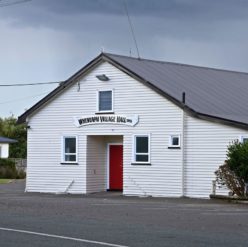
Malcolm Hahn Reserve, at the Whenuapai village hall with tennis court, play area and bush walk .
Bill Moir Reserve, in Waimarie Road, with toilets, play area, sports field and exercise circuit
Riverlea Reserve, with a lot of open space and water access
Dale Road Reserve, is currently a grass field leading leading down to a mangrove inlet.
Planting and other work is being conducted on all these reserves by volunteers from the local ecological group, Living Whenuapai, with plants etc. from the UHLB.
Even so, there is woefully insufficient open space for the rapidly growing population of the Whenuapai area and the R & R have been lobbying the UHLB to purchase more land for reserves for the people to use..
Note :-the North West Wildlink is a concept, not an official document.
Kauri Road land
There is an area of land, to the left when travelling Kauri Road to the city, opposite the golf course. Currently this is all zoned “Future Urban”.
Under “Plan change 5”, a group of 3 developers had requested that the northern part (where the air force have yellow landing-light towers) should be zoned “special purpose”, but the much larger southern part be rezoned “Light Industry”.
Currently the whole area, (North & South) which is owned by the Crown (Defence Force, has a Designation “NZ Defence Force” (which includes the airfield itself)
“Designation” over-rules “zoning”.
But:- what happens if the “Designation” is no longer required ?
i.e. the air-force moves on, or ? ( see below)…….
In any case the Southern part is not really used by the Defence Force now (except for dog training) and there is a real risk it would be meanwhile sold by the Crown, irrespective of any relocation of the airforce (remember the new P8 Orions will have to move to the longer runway at Ohakea).
As of mid June 2022, Plan Change 5 (to the Unitary Plan) has been withdrawn, so the development aspect is currently no longer an issue, but there is still a case for the land to be available to the public. (there is controversy over the earth-capped 13m deep old airforce dump on that land)
The R & R have lobbied the UHLB, who replied that the area is too big for their budget to purchase.
The R & R are continuing to lobby the MP Chris Penk, with the aim that the Crown gift the Southern part as a reserve. He agrees and has written to the Minister of Defence and raised this on floor of Parliament, and written to Phil Goff (no reply after several months)
Council land, corner Trigg & Spedding Roads
Background
Auckland Council have a policy document is ruling.
There is a Council “Open Space Acquisition Policy” .
From Upper Harbour Local Board (UHLB) there is also a Whenuapai Structure plan.
There is a sum available for land purchase, but that is confidential,
The land
About 2 ha have been purchased by the Council at the inside corner of Trigg & Spedding Roads, which they have leased for grazing. Long term it is intended to build an indoor sports complex.
The R & R have lobbied to the UHLB for access now to that land.
It could for example be used as an off-leash dog park to replace the informal area currently used near the Whenuapai shops corner Brigham Creek & Totara Road) which will be developed as Commercial by Oyster Developments
The R & R have also lobbied to the UHLB for more land than is currently available